


Basics
- Location:
- Southwestern Oregon through Rogue River and Umpqua National Forests
- Surface:
- Paved
- Length:
- 172 miles (276 km)
- Time:
- Eight hours to enjoy this Byway
- Season:
- Drivable year round
Description
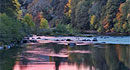
The Rogue-Umpqua Scenic Byway, more commonly known as the "highway of waterfalls," lives up to its nickname. Traveling past countless bodies of water, major rivers, and waterfalls, this drive delivers a fluid and memorable experience of southwestern Oregon and the life-aquatic.
The Rogue-Umpqua Scenic Byway starts in Roseburg, 71 miles south of Eugene. From Roseburg, travel east on HWY 138 and then onto HWY 230. The road eventually turns into HWY 6 and then HWY 230 shortly before Gold Hill where the byway ends.
All types of water sports and activities are plentiful and easily accessible. Perhaps the most unique spot along the drive is Colliding Rivers, where a unique geologic phenomenon causes the North Umpqua River and the Little River to meet head-on, the only place in the world where this happens. The scene here is truly incredible during the rainy season. Another unique place to visit is the famous Crater Lake National Park, a deep and pure lake hanging high in a crater formed volcanically 7,700 years ago. Take the drive around the 33-mile rim of the crater or hike down the Cleetwood Cove Trail to explore the lake by boat.
 The difficult task you face in Roseburg will be deciding what to do. The area offers 32 scenic hiking trails, 24 gorgeous waterfalls, internationally recognized fly-fishing and a unique 600 acre drive-thru wildlife park: Wildlife Safari. You could also enjoy a tasting at 21 local wineries, or a visit to nearby Crater Lake, one of the SEVEN WONDERS OF THE WORLD!
Helpful Links
Points of Interest
Points of Interest Along The Way
Apple Creek Area (OR)
Apple Creek Area provides visitors a combination tent-auto-trailer camping site and one combination multiple family site. Trails lead to the North Umpqua River and there is an access to the North Umpqua Trail.
Directions
Located along SR 138, about 42 miles from Roseburg.
Baker Wayside (OR)
Baker Wayside is often used for fly fishing access, and sometimes used as a boat launch. The Park has 5 picnic units and a new vault toilet. Baker Wayside is located just above Baker Falls and provides good access to the North Umpqua River.
Directions
Located along SR 138, about 24 miles from Roseburg.
Bogus Creek Campground (OR)
Located in the heart of the Western Cascade Mountains, Bogus Creek area is popular with anglers, rafters and family campers. This site provides 15 campsites, three multi-family campsites, whitewater access to the North Umpqua River and hiking opportunities. Nearby attractions are waterfalls, rock formations, river views and the North Umpqua Trail. This site is a major launching point for whitewater boaters. A whitewater interpretive display is located on-site.
Directions
Located along SR 138, about 34 miles from Roseburg.
Boulder Flat (OR)
Boulder Flat is a campground located next to the Rogue-Umpqua Scenic Byway and adjacent to the North Umpqua River. Campers may enjoy the sound of the river from their campsite. The area is frequented by boaters and fly anglers. Boulder Flat Campground has two vault toilets and ten campsites with individual picnic tables and fireplaces. Visitors can enjoy the crystal clear waters of the North Umpqua River.
Directions
Located along SR 138, about 52 miles from Roseburg.
Cable Crossing Wayside (OR)
Cable Crossing Wayside provides a beautiful view of the North Umpqua River. The site has one vault toilet, one picnic unit, and one barbecue pit. Cable Crossing is used by some for fly fishing access and as a boat take-out location.
Directions
Located along SR 138, about 22 miles from Roseburg.
Casey State Park (OR)
Located on the Upper Rogue River, this small Oregon State Park is a day-use facility and a very popular fishing and boat launch site.
Clearwater Falls (OR)
This 30-40 foot cascade is only a short walk up Clearwater River. The falls cascade over moss-covered rocks and logs. It is a breath-taking and picture-perfect view. Visitors may camp and picnic at this area.
Directions
Located along SR 138, about 70 miles from Roseburg.
Colliding Rivers (OR)
This is the site of a unique geologic phenomenon that causes the North Umpqua River and the Little River to meet head-on, the only place in the world where this happens. Views are most spectacular with higher river flows during the wet season. The newly reconstructed interpretive and rest area includes a short accessible nature trail. A historic Civilian Conservation Corps structure built in 1938 is used as a Visitors Center and open May through October. Brochures, maps and books are available at the Center.
Crater Lake National Park (OR)
A side-trip off the Rogue-Umpqua Scenic Byway, where State Highway 230 joins with State Highway 62, visit Oregon's only National Park. One of the Cascade's finest features, this huge caldera resulted from the cataclysmic explosion of Mt. Mazama 7,700years ago. Take the 33-mile Rim Drive around the caldera, or hike down to Cleetwood Cove Trail to catch a boat ride on the deep blue water for which Crater Lake is world-renown.
Directions
Located about 23 miles off of SR 230.
Crater Rim Viewpoint (OR)
Crater Rim Viewpoint provides a panoramic view of the mountains surrounding Crater Lake National Park. It provides access to the Upper Rogue River National Recreation Trail and the Boundary Springs Trail. Boundary Springs, located within Crater Lake National Park is an incredibly beautiful series of moss-covered springs that form the beginning of the Wild & Scenic Rogue River.
Directions
Located along SR 230.


